I came across this old Polaroid photo while going through my archives and I was struck with a wave of nostalgia. I don’t remember the exact date I shot this scene but a safe guess would be the late 1960s to early 1970s. The vantage point is from the US 27 overpass in Richmond looking to the west. For fun, I decided to scan the old photo and shoot the present day scene for comparison.
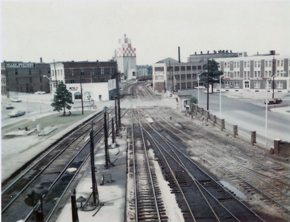
PRR station trackage looking west, circa the late 1960s – early 1970s.

The same vantage point in September, 2014
These photos, taken forty years apart, reveal many things that aren’t obvious at first glance. Going beyond the drastic changes to the track structure and the missing buildings, one can discern many other changes. You’ll note the preponderance of oil soaked ground in the older photo. Westbound PRR passenger trains would top off their fuel tanks during the station stop from the fuel racks next to the main. I vividly recall the fuel tender and his indifferent attitude toward running tanks over. Many’s the time gallons of diesel fuel spilled over onto the ground until he returned to shut off the flow.
Younger modelers brought up in an age of environmental sensitivity may find that hard to believe but it happened, regularly. Today, strict environmental regulations and cost saving mandates driven by the price of fuel rule all forms of commercial transport.
One might also glean some insight to the economic status in this part of town. The areas around the depot were in sad shape in the 1960s, with the 1970s being the bottom of the slide. Since then things have rebounded greatly. There is now a genuine sense of a small neighborhood featuring many shops, eateries and other businesses. The Daniel Burnham designed passenger depot recently underwent a multi-million dollar restoration and the area is now a thriving part of the overall community.
For the railroad, traffic began its decline in the 1960s and truly plummeted during the Penn Central and Conrail years until this line came under Norfolk & Western (NS) control in the late 1980s. NS eventually removed the trackage it didn’t need and significantly upgraded the rest.
I write a lot about learning to see details and how to discern the essence of a scene or object and TMC Vol. 10 is dedicated to this topic (available later this month). I write about applying techniques from art and painting to modeling as a way of understanding the connection on a deeper level myself and also to share these insights so that you can apply them to your own work.
Our tendency as modelers is to focus on the obvious: the track plan, the trains, operations and we treat surrounding scenery like filler. but when given careful thought, such scenery can play a larger supporting role in the narrative we’re telling.
For old times, let me ask: what do you see here?
Regards,
Mike
Hi Mike,
Great comparative shots!! Is this upstate New York? I am pretty sure it is NOT Richmond, Virginia. From my perspective these two photos show a vivid snapshot of pecuniary change. Beginning with the accelerating economies that drove the industrial revolution in the United States -dating back to the mid-nineteenth century or earlier- moving ahead a century or so through two World Wars, and concluding with a photo foreshadowing the sputtering decline of the 1970s that predates the end of the Cold War. This evolving railroad right of way tells an interesting and sadly common regional/national story.
The little red car at right will allow future historians to date the second photo but it is interesting how the scene changes from 7-8 tracks to just really 1-2. Most telling is that in many areas across the country, as economic recovery reshapes various industrial, urban, and suburban environs, there are often just far fewer railroad tracks to go around. While more powerful locomotives, larger and heavier cars, and longer trains may move more cargo today (?) it is all done within a much smaller geographic and industrial footprint. Not to mention limited crew sizes.
The oil spills pictured on the main, which reflects for me the general ennui of the 1970s, is the most powerful image I take away. Many modelers like that period because of the splashy paint schemes flowing out of the merger movement and all those colorful short line boxcars scattered about, not to mention the last gasp of many intriguing older locomotive types, but overall the national railroad economy was on life support.
Perhaps the first photo just shows that the entire massive and extremely expensive infrastructure that anchored the earlier rail transportation system was simply no longer needed. But all of the track was still there no doubt hauling less, but was there nonetheless for complex economic, political, and managerial reasons.
I recently took a similar shot in Virginia a few weeks back of a rural spot that changed for different reasons and this gets me to thinking….
Best,
Gerard
Hi Gerard,
The scene is in Richmond, Indiana on the former PRR Pittsburgh to St. Louis line.
The trackage of the first photo reflects significant changes made by the Pennsylvania when it consolidated the assets of the merged lines in this area. This track arrangement dates from the turn of the twentieth century and lasted until the 1980s, the time of the Norfolk Western takeover.
The first photo shows the infrastructure of peak traffic levels that lasted until WWII and then through the beginning of the end over the next thirty to forty years.
Today it’s a major NS secondary main from Cincinnati to Chicago with frequent daily traffic. Interesting note from an NS conductor who told me that all local traffic is inbound only. Whatever leaves town does so by truck.
Regards,
Mike
Mike,
What ever became of the brick fence and wonderful block building at the end by the road. A shame such nice work has been removed over time. Much, besides track is missing in the now.
Matt
Hi Matt,
The fence and little block building were removed in the 1970-80s. I’m a bit fuzzy on the exact timing. The small building was actually a tower that controlled the crossing gates. The base seen in the before shot was dressed stone and held a wooden top with a pyramid roof. I’ll have to find some photos I can get permission to post for. It was an interesting little structure built in the typical “it’ll last forever” Pennsy fashion.
It’s very hard to see but there was an interlocking tower for train movements in the distance to the left of the line of boxcars near the Purina plant.It’s just peeking out from the back edge of the three-story brick building with the white facade.
I’m getting the sense I will have to post some more photos of the area. 😉
Regards,
Mike